Showing posts with label walks. Show all posts

Sunday, May 27, 2012

The stone wall of Wezemaal


According to popular belief, the stone wall of Wezemaal goes back to the Middle Ages. Records indeed prove that count Arnold of Wezemaal owned a vineyard back in 1254. Wine growing in the region might even go back as far as the 11th century.

From the 14th to the 16th century, cultivation of wine in the Hageland had its ups and downs. It stopped abruptly in 1570. Competition from the (better) German and French wines, the success of hop beers and a change in climate all contributed to this decline.

From then on, no wine was grown, until J F Audoor, a civil servant from Brussels, obtains permission from the Count of Ursel to start a vineyard. He recruits a viticulturist from Hoei to establish a 6 ha vineyard in 1817. By 1834, already 32 ha are being cultivated. In 1828, a record production of 32500 liter is achieved.

Both King Willem I (before 1830) and King Leopold I (after Belgium’s independence) looked favourably on wine cultivation in Wezemaal, but nevertheless, production stopped again in 1845.

Except for a timid attempt by Adolf Schuler in the thirties, Wezemaal was again without wine culture for well over a century. In 1982, a group of local enthusiasts, with strong support from the municipality, established the association ‘Steenen Muur’ and started 3 vineyards for a total of 0.7 ha. Today, Wezemaal, part of Rotselaar, aims to profile itself as a wine village in Flanders.

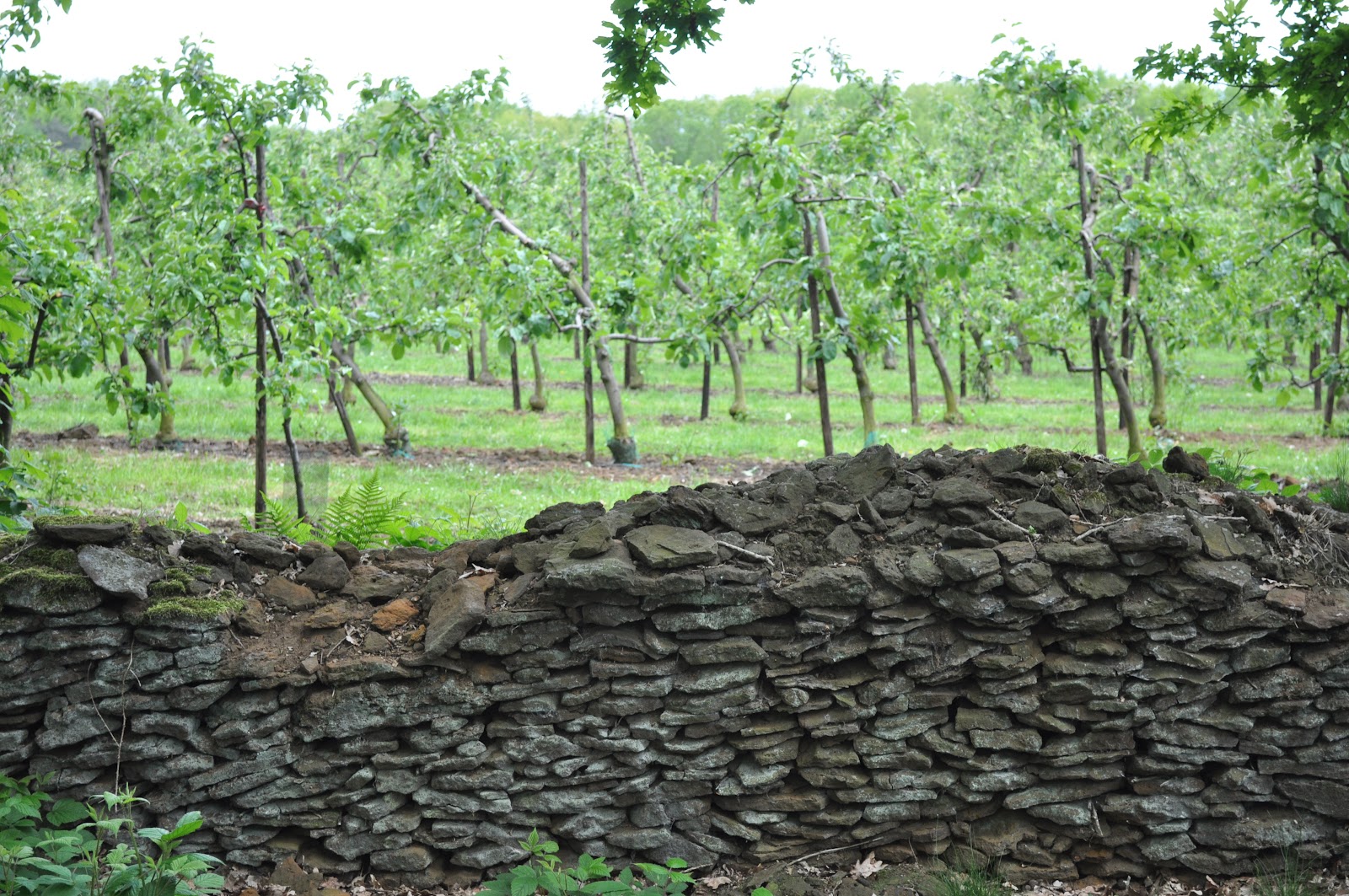
So what’s the story behind the wall? It’s not medieval. Instead, it’s a relatively new construction dating from 1814 (one year before the battle of Waterloo). It was constructed to protect the southern slope of the Wijngaardberg (literally “Vineyard Hill”) against the cold north wind. As secondary benefits, it served to keep unwanted animals out, and acted as a demarcation line. The wall was constructed by stapling iron sandstone found on the hill.

Why the need for this wall? At the time, it was believed that wine could not be grown above 50 degrees latitude. Wezemaal is at 51 degrees (approximate latitude of Brussels, Louvain, Cologne), which made its vineyards the most northern ones in Europe in the 19th century.

Despite its northern location, the Wezemaal Wijngaardberg combines several ideal conditions. The southern slope optimally captures sunlights, while the iron sandstones underground store heat that they slowly release at night, so that the soil does not cool down too much. Cool air rolls down the hill and the wind quickly blows morning dew away. These conditions create a suitable microclimate.

Meanwhile, there are plenty more vineyards even further north of Wezemaal, e.g. in the Netherlands, and Wezemaal is no longer Europe’s most northern vineyard. Are these growing wine cultures in Belgium, Netherlands and Southern England facilitated by climate change?

The wall can be visited by a 3 km walk, which takes you through the middle of the vineyards. The wall itself is 1546 m long, and was originally 1.7 meters wide and up to 2 meters tall. Meanwhile, many stretches of the wall are badly damaged, and vegetation has taken over much of the function of the wall. There is also a longer, 8 km walk available. Both walks are clearly signposted.

The short walk starts at the chapel in the Beninkstraat in Rotselaar. The long walk starts at the visitor centre for the wine in the region.

More information

Saturday, May 12, 2012

The Beguinage of Leuven - a brick symphony


Since its restoration in the 80s, the beguinage of Leuven has become one of the major attractions of the city. Among Belgium’s ~30 beguinages, this is one of the larger ones, and it has been well preserved in its integrity, including its outer walls and some of its gates.

At its peak, almost 300 beguines lived in this miniature city of seven streets and around 100 buildings, of which 11 community houses. Today, the beguinage is used for student accommodation, and for hosting visiting professors and their families.

The Leuven beguinage was founded early in the 13th century, sometime between 1205 and 1234, when a group of women moved to the neighbourhood near St Quinten’s church to establish a religious community. The beguinage was recognised in 1250 as a parish, and placed under the protection of the abbot of the Cistercian Abbey of Villers-La-Ville. The beguinage church was constructed in the 14th century. A golden age started for the beguinage. Through many gifts, it became a rich institution, and reached its peak in the 17th century.

The current restoration in Flemish renaissance style is based on this period. The University of Leuven took over the derelict buildings in 1962 and started to restore them with much attention to detail, while accommodating modern technologies. Ironically, the beguinage probably never looked in the past as it looks today - rather beguinages were architectural ensembles hosting buildings from various centuries.

As this is the second article about beguinages on this blog, and certainly not the last one, let’s spend a few words on this movement which started around 1200. Why did these women, wishing to lead a religious life, establish beguinages and not convents? After all, monastic life was booming in the Middle Ages, with plenty of religious orders to choose from. However, joining the order, with its vows of poverty and obedience was not for everyone. For many women, the beguinage offered an attractive alternative between the limited options of marriage and the religious order. Moreover, due to almost continuous warfare at the time, there was a surplus of women in Europe. Beguinages attracted widowed in addition to unmarried women.

These beguines did not take vows and could leave the beguinage without repercussions. Beguinages were located inside cities, and beguines could leave the site to visit town (under certain conditions).

This helps to explain why the beguine movement was largely confined to women. There were some male beguines, but for men, there were many more alternatives. They could pursue many professions, including a career in the military. Moreover, there was no surplus of men.

Other questions remain why the beguine movement was limited to North-West Europe, or why only the Flemish beguinages survive until today, at least as architectural heritage. We’ll address these questions in a future article.

If you plan a walk through the city of Leuven (Louvain), by all means pass by the beguinage. Nearby, you can also visit St Quinten’s Church. Or have a casual lunch at the Dijlemolens.

References
  1. Diriken, Pierre. Geogids Leuven. Kortessem: Georeto, 2006. Print
  2. "Flemish Beguinages." World Heritage Centre. UNESCO. Web. 06 May 2012. http://whc.unesco.org/en/list/855
  3. Van Den Hoek, K.A. Dwalen Door Leuven. Lekturama, 1988. Print

Saturday, January 21, 2012

Walking in Belgium's colonial past


The first reference to the name Tervueren dates back to 743 A.D. in a description of the life of Saint-Hubert, Patron Saint of hunters, who allegedly died in Tervuren in 727. Still today, mass is celebrated in Saint-Hubert’s chapel each year at the end of October.

In 1897, one of the seven times when Belgium organised a world exhibition, King Leopold II selected his Congo policy as the central theme for the exhibition. On the former hunting grounds of the Dukes of Brabant - that had been neglected for the past century - a "Colonial Palace" was built and the surroundings were transformed into a beautiful park. The Avenue de Tervueren that connects the Colonial Palace to the Cinquantenaire dates from the same period.

After the 1897 exhibition, the Colonial Palace became the permanent host to Belgium’s Congo collection. It quickly became too small, and the collection moved to a newly constructed Royal Museum for Central Africa, which remains a world-class museum in its field until today. Originally, the Museum was only a small part of a much bigger complex, which included an international school and a university campus. These plans were however never realised.

The walk starts at the church of Tervuren. Walk through the monumental gate to the park. There, you’ll find node number 4 of the walking network ‘Zuid Dijleland’. Following the arrows first to node number 41, then node 42 and back to 4 takes you through the most interesting sites of the Tervuren park. The walk is around 6 km in length. Some of the highlights:
  • Church of St John Evangelist
  • Chapel of St Hubert
  • Colonial Palace
  • Royal Museum for Central Africa
  • Spanish House
  • Park of Tervueren
Practical information can be obtained at the Tourist Office of Tervuren. Among other things, you can obtain the map of the walking network ‘Zuid Dijleland’ which lists total 300 km of walking paths.

Friday, January 20, 2012

Herisem walk


Belgium is an extremely developed country. In its highly cultivated landscape, there are hundreds of recreational walks in the range of 5 to 15 km which can be enjoyed all year round.

Just 15 km out of Brussels, Beersel offers a number of walks in the Pajottenland. One of these, the Herisem walk is about 7 km. Once you’re out of the centre of Beersel, the walk is largely across quiet roads, some unpaved, some sunken. This walk is nowhere near adventurous, but you’d need to put on your walking shoes.

While the walk is well sign-posted by hexagonal plates, a few signs are missing due to construction works. So you need to get a map from the tourist office. This map lists not only the Herisem walk, but 3 other walks in the area of Beersel as well as a cycling route. The tourist office is inside the Lambiek visitor centre, where you can learn about the 1,500 years unique brewing tradition of the region.
Back to the walk, it starts at the Church of Our Lady in Beersel, a mini-cathedral and sanctuary. Turn left on the Brusselsesteenweg, then turn right at the Colruyt. Follow the brook.

This brook, called Molenbeek flows into the Zenne. It is only 8 km long, with a decline of 70 m. It is so narrow that you could easily jump over it. Yet no less than 21 mills were once active along the short and narrow brook and its branches, and at least 15 of these were paper mills. Even in ancient times, the city of Brussels was in great need of paper.

In the middle of the walk, you’ll cross the Herisem paper mill, an amazing site of industrial heritage. It dates back to the 8th century and rightfully lends its name to the walk.

Continuing, you’ll have a view on the valley of the Molenbeek, pass alongside the Begijnbos forest and end in a sunken road which leads you back to the starting point.

The scenery is a mixture of the brook, forests, agriculture and a few historic buildings. If you’re lucky, you’ll see one of the famous Brabant draft horses in the meadows.

A few impressions from the walk on a beautiful autumn day:

Wednesday, September 28, 2011

Comic strip walls in Brussels


Belgium is not only a country of beer and chocolate. It also has a rich comic strip culture, with characters such as Tintin, The Smurfs, Lucky Luke, Largo Winch or Blake & Mortimer, to name just a few. For the comic strip fan, there are plenty of things to do in Belgium.

Since 1993, the city of Brussels started to integrate comic strips into the city’s architecture. So far, there are well over 40 comic strip walls dispersed throughout the city (35 inside the ring, 8 in Laeken). These walls typically use side facades, and blend in well with the urban landscape. Some add a touch to an otherwise dull landscape. Others are meant for urban regeneration. The walls are best visited by walk.

This walk takes you all over the town, and is a nice way to discover some of the less frequented areas of Brussels. Doing the entire walk will take the best part of a day, but the walls come in groups, and you can select a segment of the walk that suits you best. Look at our album map of the walls where you can identify a center, southern and northwestern group of comic strip walls.


Comic strip walls in Brussels weergeven op een grotere kaart

Other things in Belgium for comic strip fans: